

TerraMetrics.ag
Sentinel GreenReport®
Accessible through the terrametrics.ag website, the TerraMetrics Sentinel GreenReport ® features maps at a higher spatial resolution (10 meters) than our traditional GreenReport ®. The Sentinel GreenReport ® is a web-based application that combines up to ten years of Sentinel-2 imagery, USDA NASS Cropland Data and other data layers to visualize NDVI and NDVI changes over time.
> The Sentinel GreenReport ® uses Sentinel-2 satellite imagery.
This means that the Sentinel GreenReport® provides information at
a sub-field spatial resolution (10 meters).

Sentinel GreenReport®:
•Higher spatial resolution (10m)
•Frequent updates… 5 days
•Field Level NDVI profiles
•Cropland Data History
•Full Archive Since 2017
Sentinel GreenReport ® Application Case Studies:
Wind – Iowa Derecho
August 10-11, 2020
In August 2020, a major derecho weather event swept through Nebraska and Iowa and then continued through Illinois and Indiana. The photo below (click to enlarge) shows evidence of property damage as well as damage to a corn field. High winds in August in the US corn growing areas are extremely detrimental to yield as the corn ear is just filling out its grain kernels. Corn stalks laid over in fields will not stand back up after the storm and recover, making harvest much more difficult and further compromising yield.

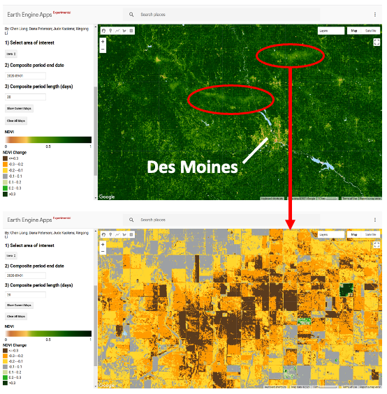
Insurance adjusters, among others, needed to know where and how extensive the derecho damage was. Using TMAI’s GreenReport® we were able to locate bands of reduced greenness (lower NDVI) north of Des Moines, Iowa. (image below – click to enlarge). Using the Sentinel GreenReport program it was then possible to identify field-level damage (second map below) and create an NDVI difference map comparing last year’s satellite imagery at the time. This revealed several areas of major damage from this derecho.
Water – Kansas Flood
May-June 2019
In May through early June, 2019, Eastern Kansas experienced major flooding. The photo below (click to enlarge) shows the Neosho River on May 7.

The GreenReport® map below (click to enlarge) shows the Neosho River and Cottonwood River joining near Emporia, Kansas indicating major issues in these river valleys. Farmers in this region either they didn’t get their crops planted on time due to flooding or the seeds were under water for quite some time.

This had a huge impact on local crop yields and was all clearly visible using TMAI’s GreenReport® and Sentinel GreenReport technology.